S&F Hero: The Eastern Part of the Polish War Theatre
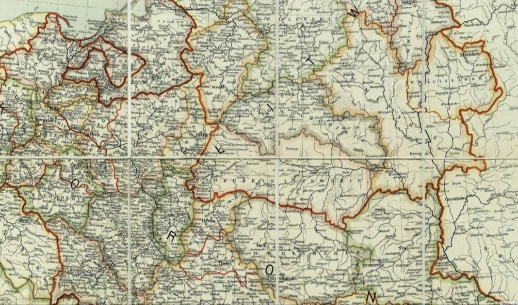
Map of the Polish-Lithuanian Commonwealth, 1771 (photo: easteurotopo.org)
The areas east of the Niemen and the Bug to the Dnieper and Daugava, and in the northern part also outside the Daugava are for Poland and Russia a centuries-old war terrain in the buffer zone between both core areas of Polish and Russian land empires. From the point of view of the former Polish-Lithuanian Commonwealth, it encompassed the eastern buffer areas of the former land empire, which gave strategic depth to the heart of the state on the Vistula line and protected against the pressure of the growing and increasingly threatening empire of the tsars.
For example, after the Treaty of Riga of 1921, this zone crossed the state border for over a thousand kilometers from the mouth of the Zbrucz to the mouth of Dzisieńka. The southern wing of the war zone was closed by the Carpathians and the borders of pre-war Romania, and in the north by the Daugava River in today Latvia. On both sides of the border from the Riga Treaty there were no special differences in the physiography of the country. The communication system of the entire zone was also uniform. The system of railways coming from the east from the Dnieper and Daugava basins from St. Petersburg to Odessa converged concentrically towards the lands of Central Poland – to the forward war bastion of former pre-revolutionary Russia in the European War Theater.
The importance of the eastern territories of the Commonwealth was appreciated by many former Polish strategists. Ludwik Mierosławski sought to concentrate the Polish army on the Dnieper and the Daugava River right at the Smolensk Gate – “the ridge separating Orsza from Vitebsk as the highest geographical key of the eastern provinces.” As he wrote – “this is a strategic surveillance site for Poland and the position of its avant-garde towards Moscow”. The next line of defence is the concave line of the Niemen and the Bug, extended by the line of the Boh and the Dniester in Ukraine. The guard of this line, strengthened by fortresses at Grodno and Brest, stands in the south cutting into the Podolian plateau in the shape of a defensive bastion at Lwów, and in the north the Lwów-equivalent – Wilno, acting as a forward positions east of the Nieman. As a strategic axis of these borderland areas, the Niemen plays an analogous role in the east of the country as to be played by the Vistula within the country itself. In its upper reaches, the Niemen flows among numerous and forested – therefore difficult-to-pass – marshes, before entering the hilly terrain, where – cutting deep into the terrain – there are steep (even up to 30 metres) and forested banks all the way to Kaunas, at which point it acquires the features of a very lowland and lazy river. At about 200 meters wide in the middle of its course, it is a serious barrier – impeding the directions of a Russian attack from the Smolensk Gate. From the Niemen through the Białowieża Forest, which is also a barrier to reckon with, we come to the middle-Bug, offering cover to the Polish heartland. The Bug, which flows northwards from Drohiczyn, then makes a semicircle, turns gradually westwards, and after reaching the right-bank tributary of the Nurzec, it flows clearly westwards. It glides lazily in the vast swampy valley, which is only possible to cross only at fords. In addition, this is a serious terrain obstacle.
Polesie is connected here with Podlasie, which then passes smoothly into Mazovia, located on both banks of the Vistula, first with the characteristic Warsaw suburbs and then the central communications hub of the capital itself. The Podlasie operating theatre, which follows a natural corridor from the Niemen, is a slightly undulating plain, gently sloping behind the Bug, reaching through Dęblin, Chełm and the Augustów muds. From the east its borders are the Bug and the Niemen, from the west the Orzyc and the Narew, and then the Brok-Kałuszyn-Żelechów-Dęblin line. Behind this line is where the Mazovian was theatre begins, dividing into central and northern parts, where the central part – based in the south on the Lesser Poland Upland – is bounded by the Bug and the Narew in the north, and the northern part of the Mazovian theatre contains Warmia, Mazury and the Drwęca River.
Just as the Niemen separates Lithuania from the Land of the Polish Crown and Red Rus, the Boh River divides Ukraine proper from Podolia. Mierosławski believed that this three-cell chain (reaching from Königsberg to Chersoń) marks the western border of a belt, whose eastern edge is the Dźwina (Daugava) and the Dnieper. “Running perpendicular to the Dnieper valley, the Pripyat separates Lithuania from the Ruthenian lands and creates two war chessboards – equal in volume but very different in purpose.” The outstanding staff officer of the November War of 1830-1831, Ignacy Prądzyński, devoted a large part of his considerations to the eastern dimension of the Polish theatre of war in an extensive and interesting chapter of his Memoirs: “There have always been two completely separate theatres between the Poles and Moscow. Whoever held Polesie could transfer his troops in mass from one to another.”
The entire vast space between the “distant Dnieper and the home Vistula” was named by Władysław Sikorski to be the vast “Sarmatian Plain”. The geography of that zone demanded the application of maneuver warfare developed by Napoleon. Its principle is that you cannot move yourself away from the operating base during the bold maneuvers, as Tuchaczewski did with catastrophic effect (on himself), departing without securing the communication lines from the Smolensk Gate. Napoleon did the same, incorrectly breaking away from the operating base located on the west side of the Smolensk Gate and generally from the Dnieper and Daugava lines. The emerging strategic depth of the opponent in the buffer zone between Poland and Russia simply “draws and drains” the fighting forces.
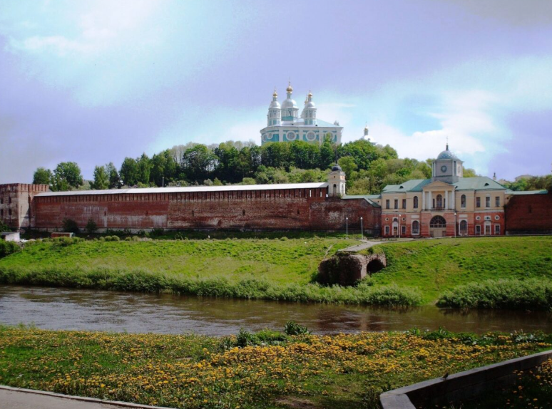
Dnieper river in Smolensk, assumption Cathedral in Smolensk visible in the background
Napoleon, when choosing the theatre of operation in the summer of 1811, discussed the plan of expedition in Paris with Józef Poniatowski and Michał Sokolnicki. The French emperor rejected Polish proposals to develop operations in the south-eastern borderlands of the former Polish-Lithuanian Commonwealth, which would have made it easier to rebuild the former Polish empire and in return he chose the strategic direction of the offensive directly towards Moscow. After taking Vilnius, he reportedly commented on this choice: “If I went to St. Petersburg, I would grab Russia by the head, if I went to Kiev, I would grab her by the legs: but if I go to Moscow, I will hit her in the heart.” The original plan of Napoleon Bonaparte did not assume a march deep into Russia. He intended to make a quick, decisive offensive somewhere between the Niemen and the Daugava, which would lead to the “political capitulation” of the tsar. Despite seizing Vilnius, abandoned by the Russians, the plan of forcing a general battle near the border failed, because the Russians withdrew deep into the country. This forced the allied forces to start chasing.
The Napoleonic army then marched on Vitebsk and Smolensk. The goal was to open the road to Moscow. After six weeks in the conquered Moscow, Napoleon’s Great Army was forced to retreat overwhelmed by the great strategic depth of the Russia. Loss in the battle of Małarosławiec forced the allies to return along the same path they had previously taken to Moscow. The Great Army in a heavy retreat crossed the Berezina river line, while avoiding being completely annihilated by the Russian pursuit, but not avoiding the terrible fiasco and defeat of the campaign.
In the Polish War Theater, in particular between the Vistula, Dnieper and Dźwina (Daguva) a bold maneuver is a king, which – combined with the element of surprise – has always given immediate and tangible results.
This is perfectly demonstrated by the war in 1919, and in the spring and late summer of 1920, both in the Battle of Warsaw and the Niemen battle that matched its scale. Observation and analysis of military operations in the first half of the twentieth century may indicate that the only appropriate defence action in the northern theatre of military operations may be the “active defence based on maneouver” hinged upon one of several strategic frontiers. In the east-west direction they were the lines of the Niemen, the Ogiński Channel and the Szczara. The eastern border was the the Berezyna and the Dźwina lines. However, due to the length of the line that these rivers formed, it was quite difficult to defend them with limited forces. The third border was the line of former German trenches from World War I.
Analysing military operations in this area (from 1914-1918, 1919-1920 and 1939-1945), one notices several characteristic phenomena. In operations a wide and fast maneuver dominates, which seeks to deprive enemy units of combat capability.
The wet nature of part of the territory, as well as the specific arrangement of rivers and forests allows the side which has combat initiative of and the ability to maneuver to efficiently surprise the enemy (even encircling them) with a seemingly insufficient amount of strength and resources. Such activities were carried out by the Polish Army during the Polish-Soviet war of 1919–1920. Often with limited forces, the Polish Army – using the terrain conditions – was able to defeat more significant enemy forces. As can be seen, operations at that time were based on a quick maneuver and outflanking the enemy, who was forced to retreat to an area unfavourable for military operations – as in the case of the Niemen operation ending the 1920 war. This type of activity was repeated in 1939–1945.
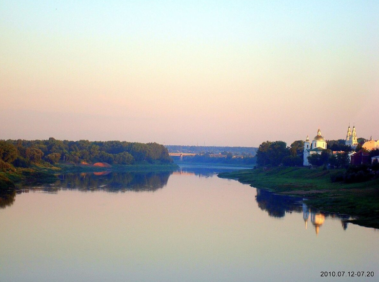
Daugava river in Riga (photo: Wikipedia)
A characteristic maneuver from this period is the German operation Barbarossa (1941) and the Soviet operation Bagration (1944).
The Wehrmacht managed to take over the Bug River and reach 50 kilometres deep into enemy territory during the first day of fighting. The main operation carried out in June and July 1941 was the encirclement of Soviet troops in today’s Belarus by the Army Group “Centre” of Field Marshal von Bock. The battle was based on an innovative maneuver to repeatedly encircle enemy forces with fast and deep strikes by motorised groups. Strong armoured groups hit from two regions. From the area of Suwałki, the Hotha group was led in the general direction towards Minsk via Vilnius. Meanwhile, troops commanded by General Guderian were to lead the attack from Terespol to Brest, and then to Minsk through Baranowicze. Within five days, the units of the 2nd and 3rd Panzer Group managed to break the enemy’s front lines several times and quickly reached the suburbs of Minsk. By 8th July, the Białystok-Minsk operation had been completed. As a result of the operation, by the end of July 1941, it was possible to reach the Berezyna and upper Daugava lines, as well as take up a starting position at the Smolensk Gate.
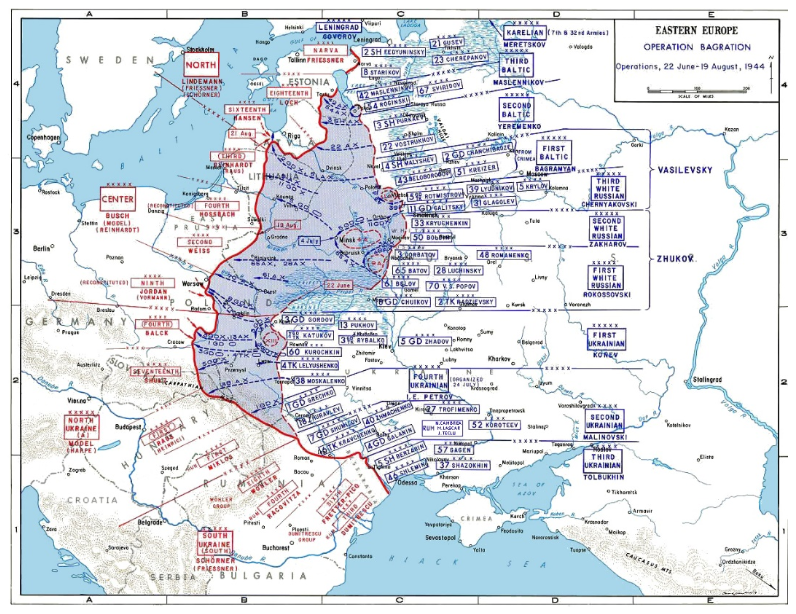
As a result of later actions in the autumn of 1943, a permanent front line was created, remaining unchanged until the spring of 1944. Soviet troops took the front line based from the north on the Smolensk Gate and further south along the Dnieper to Rogaczew. From here, the front crossed the Dnieper and Berezyna rivers, leaving Żłobin, Kalenkowicze and Mozyrz on the Soviet side, and then stretched west along the Pripyat line. Preparations for Soviet operations began in mid-April 1944 along with the development of an operation plan, codenamed Bagration. The plan developed was largely a mirror image of the German maneuver of June 1941. On 22nd June 1944, the main strikes were carried out in the following directions: Vitebsk, Orsha, Mogilev and Bobruisk. As a result of the first phase of the operation, the Soviet army destroyed most of the Wehrmacht forces in the first line of defence. After seizing Minsk, Red Army troops were to direct the offensive to the pre-war lands of the Polish-Lithuanian Commonwealth. The goals set for the front commanders assumed the capture of Brest, Grodno, Bialystok, as well as Kaunas and Vilnius. Troops of the Red Army, although exhausted by the first stage of the operation, on 5th July 1944 went on to a further offensive. As a result, the Red Army gained the position of conducting a further offensive on the territory of East Prussia and central Poland.
Plan of the Operation Bagration (photo: Wikipedia)
While the northern Belarussian theater of war passes roads from Warsaw to Moscow and St. Petersburg, connecting the capitals of the countries of the Central European and Eastern European Plain, the roads of the southern war theatre ran to the fertile provinces of the Ukrainian chernozem (“black soil”) and the Iron and Coal Basin, as well as Krzywy Rog and the Donbass and further to the Volga River system, i.e. the heartland and agricultural centre of Russia. In turn, to Poland, the southern theatre of warfare led straight to its core area with the most densely populated heartland and dangerously to the rear of Warsaw operational centre – namely to industrial Silesia, to economic hub of the Greater Poland and further across the Oder even to German Berlin, which is located just past the Oder.
Therefore, while the fate of the Polish and Russian capitals was decided in the northern Belarusian war theater, the result of a possible long-lasting war – one could say the ability to wage a attrition war – could also be decided south of the swamps of Pripyat.
Józef Piłsudski remembered the significance of the Smolensk Gate in his Rok 1920 (‘The Year 1920’): “Tuchaczewski states that when undertaking operations with a well-defined goal, he had two main directions to choose from for his main forces. One of them is called the Khumene direction, leading straight to Minsk, the other – as he says – ‘Poles call the Smolensk gate’. Tuchaczewski chose the latter direction for his operations. As I have already pointed out, our term means something completely different. Indeed, the two main rivers of the borderland that once existed between Old Poland and the tsarist empire, the Daugava and the Dnieper, form in their upper reaches a relatively narrow corridor, closed at its exit east of the largest city in that country – Smolensk. Therefore, all invasions and expeditions, be it from the Polish or the Russian side, necessarily came through Smolensk, making it as if it were a gate, to which they knocked first of all when it was about operations of larger sizes. Smolensk was conquered by one side or another over the centuries every time there were major wars waged in those days. In more recent times, during Napoleon’s march on Moscow, once again one of the major battles was fought for control of these important gates.”
The geographical distribution of the eastern part of the Polish theatre of war interchangeably indicates elements of the strength and strategic weakness of Poland. The eastern border was nevertheless too close to the heart the country. At the northern Belarusian theatre of military operations, the short time did not allow the concentration of most armies in the event of a war coming from the Smolensk Gate in the event of surprise by the Russians. Of course, this regularity is even more worrying today, not only because of Poland’s lack of control of the Smolensk Gate itself, but even because the Brest and Grodno communication nodes are located in present-day Belarus, which is under the military control of the Russians, which makes time for the Polish military response in the Warsaw direction shorter, and the response much more difficult to carry out.
In the offensive, in turn, Poland’s inherent weakness was the fact that Polish armies were leaving the “20-mile to 200-mile” area with a fan-shaped road layout in front of them. As the space moves away from the core of the state, the space in which they must operate increases not only “in length”, but also “in width.”
For Russian offensive operations coming out of the Russian core area, the opposite occurs, in turn: the buffer border between Moscow and Warsaw is a more distant area than from Warsaw’s point of view, and all military movement required a long time, including considerable preparation. On the flip side, the width of the front decreased with the success of the war with Poland, the channel of traffic to Warsaw narrowing.
In this sense, with equal strength, the Polish initiative has the advantage at the beginning of the war, and with proper mobilization and concentration, it easily gains the advantage of speeding the task. This explains the tendency of the Polish side to offensive behavior in the Polish-Soviet war of 1919–1921 and in the subsequent training of the Polish Army during the Second Polish Republic.
The western border of this theatre of warfare is only partly reinforced by natural obstacles. It is a short section of the Bug River near Brest, as well as two sections of the Niemen. The first of them extends around Grodno, while the second fragment is its lower course partly overlapping the present-day border of Lithuania and the Kaliningrad Oblast. From the west, there are the most favourable conditions for conducting a military operation due to the already mentioned lowland shape of the terrain and the lack of serious terrain obstacles. The area is characterized by a lowland low-waveguide system with a small number of significant hills. The two highest points are about 300 meters above sea level. The first of these places is located southeast of Vilnius. It is the Juozapine hill, which belongs to the Ašmiany Hump and is 294 meters above sea level. However, another such area of similar height is located in the Minsk region (the Minsk Upland). These are two mountains – Łysa (342 m a.s.l.) and Dzerzhinska (345 m a.s.l.). The continental watershed runs through the territory of Belarus and stretches from the north-east to the south-west. Approximately this division begins near Orsha, then continues towards Minsk and ends in western Polesie. The longest river stretching through Lithuania and Belarus is the Niemen. It stretches from its sources in Belarus, ending at the mouth of the Baltic Sea.
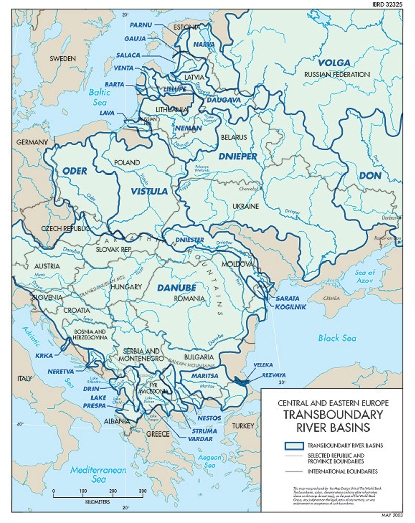
River system of Central-Eastern Europe (photo: worldbank.org)
The Niemen Valley is swampy and forested, especially around the mouth of the Szczara River. In the Belarusian part of the river course, the most important communication node is Grodno and its surroundings. There is a significant road and rail crossing here, and to the north of Grodno is the Augustowski Canal, connecting the Vistula and Niemen water divisions. In the Lithuanian part of the river course, the main circular crossings are found in most cities on its banks. Kaunas is the largest transport hub, with a total of over 30 crossings over the Nieman and the Neris (wheeled, pedestrian and rail). The Nieman Valley is a significant barrier militarily along the entire course of the river. The dense afforestation of the valley and its wet nature, as well as the abundant network of tributaries, cause difficulties in concentration of troops and their crossing. For strategic reasons, the most important are the crossings in Grodno and Kaunas. The second longest river in Lithuania is the Neris, which is 510 kilometres long. Its source is located north of Minsk, and the river ends its course flowing into the Niemen in Kaunas.
On the Belarusian section its course is irregular – it changes its direction several times. However, it flows latitudinally from the Lithuanian-Belarusian border. Of course, the Dnieper, along with its two main tributaries in Belarus (the Berezina and the Pripyat) is also of great strategic importance. On the Dnieper there are several permanent crossings around larger cities – Orsha, Rzezyca and Mohylov. The Berezyna is the right tributary of the Dnieper that runs parallel. The total length of the Berezina is 613 kilometres and it is cut through by oxbow lakes and branches along its entire length. The Berezyna Valley is largely forested and wet, even swampy. There are only a few sections where the valley is dry and easily accessible. They are located around the city of Bobruisk. The Pripyat extends through the Polesie area. The total length of Pripyat is 761 kilometres, of which 495 kilometres stretch on the territory of Belarus. The sources and the mouth of Pripyat are in Ukraine. During the thaw and rainy seasons, the Pripyat valley becomes completely impossible to cross, except for permanent crossings.
The Dnieper, the Berezina and the Pripyat are Belarusian inland roads and play an important role from the point of view of their suitability for military operations. In addition to being the natural boundaries of war operations, they can also be a means of transport for military troops, with the Dnieper and the Berezina being road routes serving the entire front. The Pripyat, on the other hand, can be a forward road.
Between Polesie and the sources of the Niemen, there is a fertile loess corridor of the Słuck through Bobrujsk to Berezyna and Rohaczew on the Dnieper, which even led to Starodub (as in the case of the Tartar invasion in 1506 or the Tarnowski expedition in 1535). Of course, the most important was, of course, the route from Vilnius and Minsk to Moscow through the Smolensk Gate, constituting the intercity of the upper Dnieper and the Daugava, about 80 kilometres wide with the tiny rivers Łuczesa and Kapsla – tributaries of the upper Daugava – as the only ones crossing the dry and elevated river basin, extremely convenient for a concentrated march of masses of troops without the necessity of always risky division. At the Smolensk Gate itself, the main road led its southern hinge along the Dnieper along a convenient road from Orsza to Smolensk. This age-old trail in the Grand Duchy of Lithuania was crossed by the muddy valleys of the Świsłocz near Minsk, the Berezyna near Borisov and the Drucia near Druck. The third passage to the east led in the direction from Vilnius to Pskov and Nowogrod, leading through Dźwina near Połock along the Łowia and Wieliczka rivers.
The Russians broke the defence system of the Grand Duchy of Lithuania at the Smolensk Gate in 1514, and on Połotsk – northern hinge of the Gate in 1560, which forced the principality’s elite to ultimately turn for help to the Polish Crown. In addition to the growing strength of the Moscow Empire, the artillery revolution also changed the rules of fortification and siege, weakening the defensive strategic line of the Old Polish Empire on the Dnieper and the Daugava.
From Polish Livonia to Polesie and from the Baltic coast to beyond the Dnieper, the areas of the North-Eastern “Polish Peninsula” can be reached, decisive for transferring the war to the Vistula River basin or the Dnieper and Daugava basin.
The area is divided into several lanes. The first is a lake district with a collection of hills and lakes, troughs and swampy broad river valleys roughly between Połock nad Dźwiną and Vilnius and the area south of Suwałki. The second belt is highlands – less steep in it, rather no lakes, there are Minsk, Oszmiańska, Nowogrodzka and Wołkowyska Uplands. The third belt is the lowlands – squeezing in sinuously between the upland patches and streaking along the river valleys: at Żmudź along the Niemen, along the Dnieper and the Berezina. There is often rainfall – in the summer, even very often and long lasting – after several days and weeks even. On this axis there are important borderland cities: Kaunas, Minsk, Vilnius, Grodno, Brest. In general, a characteristic feature is the poor communication network, the war in these spaces was a infrantry war, by and large – a foot business – until World War II, and the troops came to the fight on foot rather than commuting.
Daugava river in Polotsk (photo: Иван Бай, Wikimedia)
An interesting fact is that a decent road network was created by the Germans during World War I for the needs of logistics and stage service. However, this network disappeared quickly in the Second Polish Republic due to the insufficient population necessary to operate this infrastructure and the lack of capital to maintain it in a decent condition. In winter, the population drove straight ahead through frozen fallow, backwaters and mud, quite differently than in summer, when roadless and unpaved roads became more difficult to communicate due to rainfall. So often winter roads were completely at odds with the map of the region available to marching troops.
At present, this area is extremely convenient for terrain, slightly wavy, but without severe limitation of view in the horizon, ideal for movement and tank combat, and small hills break the horizon just enough to compensate for the potential advantage of the range of infantry firepower equipped with guided anti-tank shells, although they do not obstruct the horizon enough, enabling tanks to fight anti-tank agents at convenient distances and generally create great conditions for tank combat with its dynamics of maneuver and strength and frequency of fire.
And today this is a main operational direction threatening Warsaw from Russia. As such it consumes a lot of Polish strategic thinking as to how best to address the security threats that could potentially emanate rapidly. It is also taking away the strategic attention from the Suwałk Gap or from consolidation of the Baltic States defense. Simply put, importance of the menacing rapid maneuver from the Smolensk Gate via Brześć, Grodno and Wołkowysk into Poland’s heartland will always be priority no. 1 for decisionmakers and planners in Warsaw.
Autor
Jacek Bartosiak
CEO and Founder of Strategy&Future, author of bestselling books.





Trwa ładowanie...