Turkey and Greece: Escalation in the Aegean

(geopoliticalfutures.com)
History and Political Geography
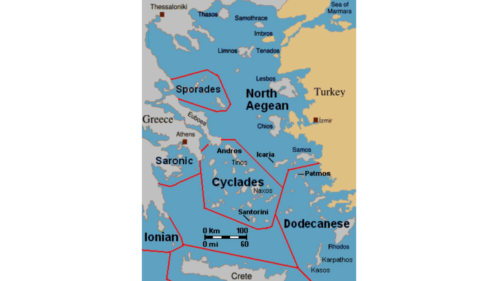
The current problem has a long history beginning in the 1970s and is deeply related to the issue of Cyprus and to the geographical nature of the Aegean Sea, which possesses one of the most sophisticated island systems in the world. It has 483 differently-sized islands. As a result of the Greco-Turkish War (1919-1922), Athens managed to establish almost full control over the sea and its islands, except the so-called “Italian Islands of the Aegean”, a group of twelve major islands (the Dodecanese). Italy owned these islands from 1912 until 1945. If not for the war, they would belong to Italy today, but the war changed everything and in 1947 they were ceded by London to Greece. The Dodecanese were a bone of contention for centuries because of their geostrategic importance. They allowed their owners to establish total control over the Turkish Straits and to block them if necessary. Moreover, the geographical position gives strategic leverage, as those who possess them, control Turkish Anatolia. For example, the Soviet Union raised the issue of the islands during the negotiations with the Allies. Moscow demanded that the Dodecanese or at least a couple of them should be provided to the Soviet Union and that Italian rule over them must be terminated.
Another important factor that shows the strategic importance of the Aegean Sea and its system of islands, is the Russian expeditions to the Eastern Mediterranean in the 18th century, known as the “Archipelago Expedition”. This was one of the most surprising military operations in history and helped Russia gain serious successes in the war against Turkey. Their main strategic advantage was that the Russian naval Squadron threatened Constantinople, Turkish Anatolia, and disturbed the Ottoman Levant and the territory of Greece. Russia even managed to build their own Admiralty in the Aegean Sea – on the island of Paros and named it the “Insular province in the Aegean Sea.” The commander of the Russian squadron Count Alexei Orlov with the approval of the Empress decided to found a Russian province on the islands of the Aegean Sea.
Rocks before oil
Till the 1970s, the situation in the Aegean Sea was more or less stable, but the Cyprus issue brought two NATO member countries to the edge of war and the strategic importance of the Aegean Sea region returned to the geopolitical agenda of both countries.
There were dangerous incidents in 1987 and 1996. The first occurred in the times of the Cold War, with both Ankara and Athens barely managing to pull back from full-scale war. The United States and other allies undertook considerable pressure on the Turkish government to halt a research vessel that was exploring for oil in the contested continental shelf around Greek islands. The pressure has not resolved the essence of the dispute and only artificially swept it under the rug of the NATO and Western alliance. Greece, while claiming a six nautical mile territory around its many islands, reserved the right to extend this claim to 12 miles. Turkey said it would view any such change in the Greek position as grounds for war, because this would effectively close most of the sea to Turkish warships. Meanwhile, Turkey refuses to recognize Greece’s 10-mile airspace limit, which Turkish fighters regularly challenge.
Additionally to this problem, both countries are in dispute over the issue of the militarization of the islands very close to Turkish coastline. For example, Greece claimed the right to militarize the Limnos island. Another key point is that the Greco-Turkish rivalry in the region already in the 1970s and 1980s had sufficiently undermined the division of NATO’s command and control responsibilities for that region. This dramatically reduced NATO’s efficiency in the region and NATO had to operate by this zone from Italy. These concerns were paramount because the US could not allow a deterioration of the situation between two allies in the region. Especially in the times of the Cold War, even though this was approaching its end. As Richard N. Haass, an American diplomat, wrote, “Turkey’s ground forces and airfields are central to American planning in the Persian Gulf and southwest Asian region. A war that would distract and divide Athens and Ankara would constitute a severe strategic setback for the West.”
The Cold War ended and the justifications for the unity ended. Ankara and Athens returned to the old dispute over the Aegean. This time the legend was a bit different – the two countries didn’t have an agreement over the delimitation of national airspace, territorial waters, exclusive economic zones and the use of the continental shelf, control over the military flight activity; the militarization of the islands and finally the dispute over the islets of Imia/Kardak. This was nothing other than an “Aegean Powder Keg.” Furthermore, all those crises and events re-occurred in the 2000s while the situation was really dangerous, but let me return to the 1990s.
In 1996, there was the next stage in this conflict. Warships, airplanes and commandos were already positioning themselves for battle when the White House and the State Department worked out an agreement for both sides to withdraw their military forces. The immediate issue involved 10 acres of rocky outcroppings less than four miles off the Turkish coast. Both nations claimed sovereignty. Their only inhabitants were 12 goats. The incident heated up after Turkish journalists flew to the island by helicopter one weekend to tear down a Greek flag flying there and replace it with a Turkish one. The Greek Navy then restored Greece’s colors, and matters escalated from there. In this period, the main concerns of the two states became more or less clear. Turkey feared that if Greece were to exercise its stated right to extend territorial sea limits from six to 12 miles, Turkey’s access to the Mediterranean through international waters would be blocked. Greek claims to control the continental shelf (believed to contain undersea oil deposits) as far east as Turkish coastal waters would be strengthened. This situation was exacerbated by Greek threats to increase the territorial limits to 12 miles offshore from the existing six, and by the unlawful militarization of the Dodecanese Islands. Turkey responded by escalating the situation. Only Bill Clinton’s personal intervention saved the situation from total disaster, after he was forced to say, “I thought my aides were joking when they said Turkey and Greece would engage in war over rocks on which none but sheep live. I held phone calls with the leaders of both countries, and convinced them to not go to war over the rocks that inhabited mostly 20 sheep.”
The EastMed Project Factor
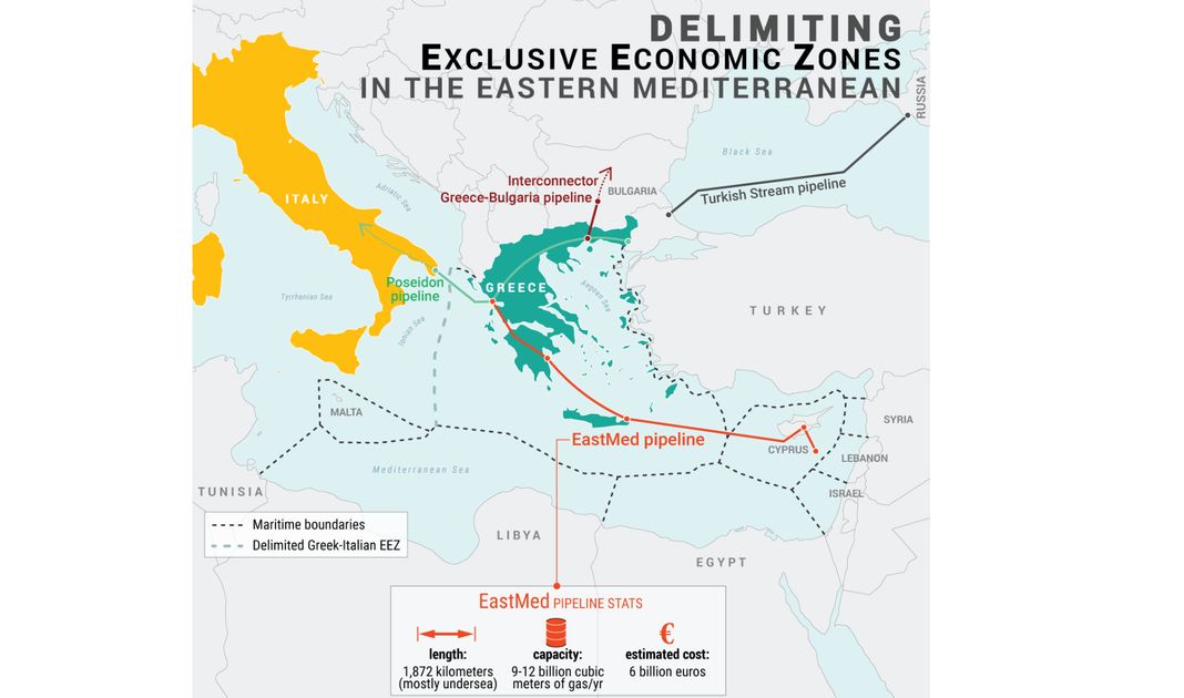
The turning point for the geopolitical history of the Eastern Mediterranean region was the date when specialists discovered gas and oil fields in this region in 2000 – the Leviathan and Tamar gas fields. The discovery of these fields gave hope to the Eastern Mediterranean countries that eventually they could be energy independent. The “energy pie” divided the region into two main camps: those ready to create a regional system of pipelines known as “EastMed”, and those who opposed this project. The situation was exaggerated by geopolitical events in the region. The most important was the Arab Spring, which actually was the main geopolitical event that postponed the process of coalition creation and of the initiation of the EastMed Project. Turkey sees this project as a threat to its national interests and worries that it can undermine her geopolitical status as a crucial regional supply hub of energy to Europe. Concurrently, Ankara – by the signing of the Turkey-GNA maritime agreement on 28 November 2019 – demonstrated the ability to conduct independent policy. But more importantly, this agreement to some extent intruded into the plans of Greece, Cyprus, Israel, and Egypt. Interestingly, Ankara didn’t sign the key documents of maritime law: the Convention on the Continental Shelf and United Nations Convention on the Law of the Sea.
Turkish Geopolitical Doctrines for the Aegean Region
Both Turkey and Greece have great unofficial geopolitical ambitions for the Aegean Sea. Turkey considers Greek possession of the islands very close to Turkish territory as a threat to its national security, and feels that such a situation must be altered. For instance, in September 2019, Recep Erdogan held a press conference near the map of Turkey’s “Blue Homeland” (Mavi Vatan) naval doctrine. In the map, the Aegean Sea and its islands were divided in twain “fifty-fifty.” This naval doctrine was developed by the prominent Turkish Admiral Cem Gurdeniz in 2006. The grand strategic idea is that Turkey should not be hemmed in the Mediterranean, the Black Sea and the Aegean Sea, which could impact the country’s trade, defense and security. Sea trade is an existential element for Turkey, therefore the freedom of navigation in the Aegean and Mediterranean Seas must be a priority. According to Gurdeniz, Turkish national memory is very fresh in remembering the maritime blockades of the Turkish Straits in the 20th century by Greeks and Italians. On 7th August, he added that “They [the Greeks] think the Aegean belongs to them, they live in a fantasy world. The current status of the Aegean Sea is that 50 percent is international waters, it’s no-man’s-land. For Turkey, the strategic consequences of allowing Greece to grab chunks of the sea have proven to be a red line.” Associate Professor Muzaffer Senel stressed that “The proximity of Greek islands to Turkey’s mainland in the Aegean Sea, act as a geopolitical containment of Turkey.”
Gurdeniz is one of the most prolific geopolitical commutators in Turkey now, and some experts compare him to another geopolitical visionary – Akhmet Davuoglu. Gurdeniz believes that Turkey must demonstrate firm responses to every Athens move in its relations with Greece: “Greece, can live inside the dream world of its past and build endless fantasies. But it should not impose these things upon Turkey’s sovereignty and interests in the Aegean, the Mediterranean, [and] the Black Sea. They should know their place.” Cihat Yayci, his supporter, the proponent of the idea of close relations with Tripoli, the navy’s former chief of staff, and in general one of the main Turkish supporters of military intervention into Libya, demanded from Athens “the return” of a sufficient number of the Aegean islands to Turkey as it was depicted in the map of the “Blue Homeland.”
Natural gas deposits off the coast of Cyprus and other zones of the Eastern Mediterranean remain a factor. In Turkey’s naval strategic concept, ground forces are called “Operation Mediterranean Shield.” Erdogan personally referred to the doctrine of the “Blue Homeland” in October 2019: “While performing our duties, we are proud to wave our glorious Turkish banner in all our seas. I submit that we are ready to protect every swath of our 462 thousand square meter blue homeland with great determination and undertake every possible duty that may come.”
Moreover, Turkish Naval Forces undertook exercises in all Turkish seas last year under the name “Blue Homeland 2019.” Ankara promotes that concept that the agreement with the GNA in Libya is a continuation of the naval doctrine of “Blue Homeland.”
Would Athens and Ankara listen to the West a third time?
A new page of this rivalry started relatively recently, since 2014, when Turkish behavior became more belligerent and confident in many strategic directions. Logically the events came to the following phase of escalation, this time in the summer of 2020. The reason was Ankara’s decision to send the research vessel Oruc Reis to the shores of the Greek island of Kastelorizo for so-called “seismic studies” in order to explore the gas fields. The works were supposed to take place from July 21 to August 2. In turn, the Greek authorities said they were not ready to tolerate Turkey’s actions, since the exploration of deposits would take place in waters belonging to the exclusive economic zone of Greece. Now the armed forces of both countries have been put on high alert. Kastellorizo is only two kilometers away from Turkish territory and it seems that Ankara is not satisfied with such a situation, when remote Greek islands are very close to Turkish territory. The economic factor is that according to Athens, despite the great length of the Turkish coast, Turkey can only lay claim in these waters for an exclusive economic zone of a rather limited size. In Ankara, on the contrary, they believe that the islands, in principle, do not give the right to be an exclusive economic zone. In the middle of July, the Greek Foreign Minister urged EU partners to prepare economic sanctions against Turkey if it does not stop geological exploration in the Greek economic zone. The French President Emmanuel Macron showed a willingness to support Athens in this undertaking. It should be noted that both Athens and Nicosia are relying on France and personally on Macron in the strategy of deterrence and containment of Turkey in her ambitions in the Eastern Mediterranean region.
Both Cyprus and Greece together with French naval forces have conducted naval exercises as a demonstration of power. Taking a quick look on the map, it is possible to see that the naval cooperation between France, Cyprus and Greece can achieve what Ankara is actually gravely afraid of – the blockade of Turkish Straits and the isolation of Anatolia from the Mediterranean Sea. And it is especially possible if France is able to restore its presence in Lebanon. The actions of Turkey demonstrate that Ankara is ready for escalation and feels that the international environment plays to her advantage. It is unlikely that the “interventions” of the US and especially from the EU would be able to stop the Turkish decision to impose the use of force against a middle-level country, either Greece or France. But both sides have kept space for negotiations and de-escalation. However, Ankara would not hesitate to respond.
(wikipedia.org)
Autor
Ridvan Bari Urcosta
Senior Analyst at Strategy&Future


Trwa ładowanie...